


 English
 Français
  Português


 Pas de réaction
 Comment!


At dawn on Tuesday 12 August 2008 our little team left Cayenne in a heavily laden 4×4. We were setting off to discover the neighbouring Guianas and our end goal was an excursion to the Kaieteur Falls in the heart of Guyana, calling in at the capitals Paramaribo and Georgetown.
We arrived in Suriname after having driven across the west of French Guiana and the River Maroni. A ferry, La Gabrielle, crosses the river that marks the border, taking about half an hour to sail from St-Laurent to Albina. And then we were on the road again to the capital, Paramaribo.
At first the change is not that great and traveller feels at home. The same yellow butterflies flutter in the hot August air, and a more or less tarmacked road goes through the same landscape of secondary forests on white sand. We went through clearings with villages of little wooden houses which are home mainly to Bushinenge populations. Shortly after crossing the border of former Dutch Guiana a stele acts as a reminder of the country’s painful past, with the “86″ monument commemorating the Civil War which divided the population nearly 20 years ago.
That evening in Paramaribo we were welcomed by Mr. B. who, like more or less a third of the population, is part of the Hindu community. He is a civil engineer specialising in building engineering structures in the region, and has taken part in the building of bridges and dykes at Mana in French Guiana. As he knows the three Guianas well he is able to compare the issues facing them. He underlined the similarities, especially in terms of their settlement with the initial Amerindian population being supplemented by people from all over the world, and especially from the former colonial empires.
Suriname is a major producer of rice thanks to its expertise in irrigation systems and polders. Polders are also found in Guyana where they are drained and irrigated by a network of channels. In French Guiana these same techniques have been used but on a lesser scale.
Towns in the Guiana Shield region are growing very rapidly, leading to the same planning problems everywhere. Major infrastructure projects are under way. Suriname is planning to build a new seaport, and there is a project to build a bridge linking it to Guyana, part of a larger plan for a pan-American road linking northern and southern South America via a road along its coast. Mr. B. feels that these elements are essential for the development of the country and its opening up to the outside world.
After having contacted the WWF whose inter-regional headquarters are in Paramaribo, we headed off westwards again along the coast. The forest progressively gives way to vast sedimentary plains covered with enormous paddy fields.
In the evening we arrived at New Nickerie, the second largest town in Suriname, and the last stopover before Guyana. This pretty little town surrounded by canals has replaced the original town of Nickerie, which was swallowed by the sea in the nineteenth century. In the morning the roads are a hive of activity. The Thursday market is held beneath the arcades and shows just how rich these frontier regions are. It is a riot of colours, smells, languages and dialects, and living proof of the mixing and blending of populations and cultures in the Guianas. In addition to the usual services such as hairdressing or video hire, you can also find a large number of different sorts of incense, amulets, and other lucky charms. Sumptuous fabrics with shimmering colours and handmade woven bracelets can be found alongside stalls selling T-shirts with the figure of Brahma or stars from show business and statuettes of Vishnu in gilt tin.
The drivers are happy to chat with foreigners on the Market Square and curious to find out about French Guiana, a place they do not seem to know much about. “But it’s a dangerous place, isn’t it?” one of them asked us. As we often found on our journey, some people are wary of their neighbouring Guianas – and unfamiliarity can breed misconceptions.
Between New Nickerie and the embarkation point on the Corentyne river there was a twenty-kilometre section of road that was being completed. At the end of the trail we boarded the ferry to cross the mighty River Corentyne. At the next border checkpoint our fears were confirmed: French vehicles are no longer allowed into Guyana. Hours of discussions and phone calls left, right, and centre changed nothing. Whilst inflexible, all the border guards were very pleasant and helpful, with a hint of “British courtesy” in the air. Mr. D. – who works on the ferry and had been keeping us company for hours – took us to Corriverton. The Customs officials had reserved rooms for us there in the hotel closest to the police station!
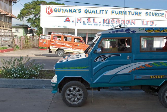
From there on we continued our journey on various forms of public transport. On the roads of Guyana there are enormous lorries packed with several dozens of people, smaller richly decorated ones known as ‘tapirs’, gleaming cars bedecked in all sorts of accessories, and carts drawn by horses or donkeys. The drivers frequently use their horns and lights to help in the traffic, which can be so dense that it borders on the chaotic. Of course, they all respect the animals that saunter around freely – donkeys, sacred zebus, cattle, and poultry.
The next day we took a taxi to drive to the capital. At New Amsterdam a ferry took us across the Berbice river. On either side of the road there are a large number of different places of worship with surprising shapes (arches and little towers, bright colours and multicoloured fabrics) – Hindu temples, mosques, and so on. Magnificent houses of equally original architecture are rendered all the more beautiful thanks to the carefully tended little gardens with their colourful Hindu flags. There are other more modest wooden buildings, often on stilts. As in the other Guianas few buildings have more than one storey.
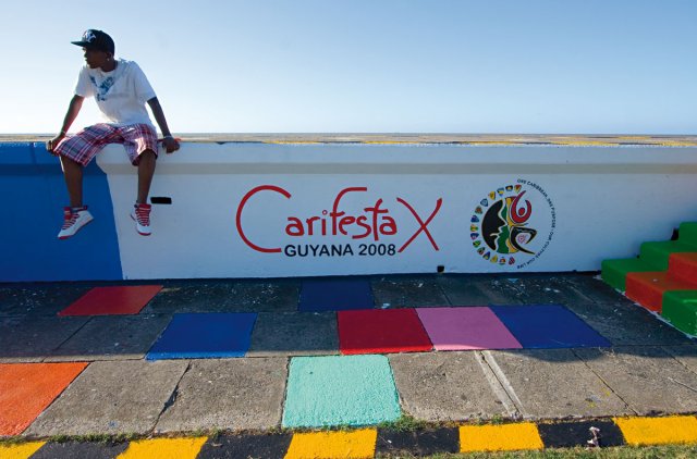
It was night when we arrived in Georgetown. As we drove into the town we were stopped by the police for a routine check. Most of the policemen were very young and they asked us if we were tourists, and especially if we were there for the Carifesta. This is a Caribbean cultural festival launched in 1972 by CARICOM (a union of Caribbean countries), and the tenth festival was due to be held in the coming days. The entire capital seemed to be abuzz as the festival approached. People had flocked from all over the Caribbean attracted by events such as the craft market and (very strong) musical scene.
We already had a contact for our accommodation –Miss N., a young law student who also worked for an estate agent, thanks to which she managed to rent out her own flat. We arrived at the address we had been given and found the Peach House, which would be our base in Georgetown. Its architecture was a mixture of different styles, as is the case for many of the houses there. Our hostess explained that finding accommodation can often be a problem as rents are very high and the housing stock is not big enough. In 2005 the population of Guyana was estimated to stand at 751,000 people (according to the World Health Organisation), of whom nearly one third lived in Georgetown.
The following day we started concentrating again on the end goal of our voyage – the Kaieteur Falls. From the scanty information we had been able to gather in French Guiana, we had learned that it was basically only accessible by plane. But we wanted to go there “by overland”, as the locals said. At the WWF they had warned us about how difficult this was, especially due to the absence of any signed trails. There was only one guide, Franck, who offered to take people there overland, and we contacted him straight away. We fixed our departure date for two days later, which gave us enough time to organise the logistics and get permission to visit the Kaieteur National Park.
We used our time to visit the town, starting with the Georgetown Botanical Gardens. The atmosphere there is very peaceful, with a large number of families strolling around and young people playing cricket, the national sport. Georgetown hosted the World Cup in 2007. We then headed towards the centre and the market around the Stabroek Hall, a vast place with a metal frame structure partly built on stilts above the waters of the Demerara River. This amazing building is home to a labyrinth of stalls held by craftsmen and traders, but it is not large enough to hold the jumble of stalls that spill out over the neighbouring streets and are overflowing with an incredible number and range of products. The colours, tastes, and smells all partake in the joyous hustle and bustle. At the edge of the market a few fishermen were having a break and playing cards on wooden crates. People were surprised to see us, as there are not many tourists. The population is very mixed, with Indians, Creoles, and Amerindians all side-by-side.
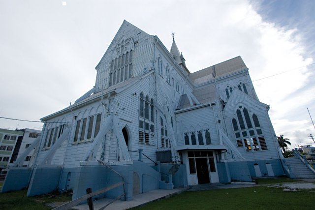
We strolled through the streets of the capital and discovered some wooden buildings with English architecture, including the famous St George’s Cathedral. This vast Gothic construction, dating from the nineteen century, is a haven of peace and cool. It is an Anglican Church entirely made from local wood, and is this – if you believe the tourist brochures – the highest in the world.
The country’s economy has recently been transformed by liberal reforms. These were launched by Mr. Hoyte in 1989, and have been continued by his successors Mrs Chaddi Jagan, and Bharrat Jadgeo, the current president of the Republic. The State has also obtained additional resources by borrowing money and privatising companies, and according to the indicators of international organisations the country has returned to positive growth.
Yet despite a more stable economic climate Guyana is still one of the poorest countries in the Caribbean and Western Hemisphere. The annual income per inhabitant is about US$1000 per year and 35.1% of the population live below the poverty line (of US$1 per day).
Life is expensive for people in Guyana, and some only manage to survive thanks to a large informal economy. As we were going about the town we came across a large number of ‘jobbers’ who did odd jobs in return for enough to eat. One of them filled sacks with crushed up seashells which were then used to make concrete. Another gathered glass bottles that people had thrown away, and others netted birds on the beach which were then sold as pets on the market.
Sunday evening in Georgetown, and everybody was at the Seawall. This dike was restored in 1976 and protects the town lying beneath the water level from the ocean. All the young people come to have a bite to eat and drink beer, while listening to music pumping out on sound systems. We also discovered the excellent local rum, El Dorado.
But it was time to head off for the Kaieteur Falls. At four in the morning Franck came and picked is up in his 4×4 and we started our nine-hour car journey. The trail was created in the 1970s and nowadays it is maintained by several multinational natural resources companies. After several hours it splits into two, one part going to Lethem towards Brazil, and the other continuing to a place we need to go through, Madhia, which was originally a gold mining* village. Every 200 metres or so a secondary track indicates that there is intensive logging in the vicinity. For that matter, there are very few trees over ten metres tall. Franck explained that the forest is one of the main natural resources in Guyana together with gold, bauxite, and diamonds. We got to know our driver better, a Venezuelan by birth and former gold miner. Gold mining seems to have a different reputation to the one it has in French Guyana, being seen as a way of making a living like any other. Apparently there is a certain camaraderie between ‘bush’ workers. The working conditions are not any easier here however. Franck explained to us that he used to have to work twenty-four hours non-stop before getting one day off. He has since switched to tourism having obtained his guide’s diploma in Caracas.
We carried on along the trail. Whenever we encountered another car the laterite got everywhere into our 4×4, the air was searing hot, and the journey was starting to become rather tiresome. We finally reached Madhia where we stopped off briefly at the police station to tell them we were there, before going on as far as the Potaro River, where a man was waiting for us sitting on the terrace in front of an old wooden house lost in the middle of the forest. It was Tony, our Amerindian guide with his dark glasses, machete stuck in his belt, and rubber boots, and he was the one who was going to be taking us as far as the Kaieteur Falls.
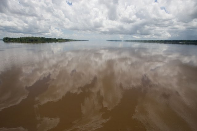
The River Potaro that we were going to be following up to the falls is amazingly clear, with a dark brown colour not often found in rivers of this size in French Guiana. The sandy soil in this region means that there is very little material suspended in water. With the sun beating down on us overhead, we were able to enjoy our first real Guyanese swim, while on the banks two Indians were cutting up half a Brazilian tapir so as to be able to transport it.
Once it was laden our wooden pirogue steered out into the waters of the Potaro, whose deserted banks are probably inhabited by many gold miners’ families. At dusk there was an impressive step up in the riverbed about the height of a tree. These are the Amatuk Falls. There is a vast white sandy island nestling in the middle, and this was where we were going to bivouac for the night. An Amerindian family lives there, and John and his son would be lending us a helping hand for the rest of our journey. With his small stature, slender moustache, and reticence, John has earned himself the nickname of the ‘soldier’. His knowledge of the forest both upstream and downstream of the falls is unequalled.
The following morning we took the trail up to the other side of the Amatuk falls, while John and his son were entrusted with the delicate mission of transporting the outboard slung below a tree trunk. Another boat was waiting for us to carry on upstream towards Waratuk, which marks the beginning of the Park.
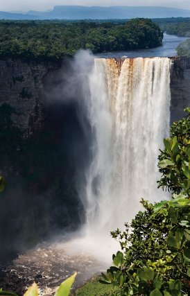
Kaieteur National Park was set up in 1929 and covers an area of 627km². It is so inaccessible that for a long time nobody lived there except the indigenous Chenapou community about fifty kilometres upstream of the Falls.
As we sped through the rainforest the landscape changed and became steeper. We entered gorges 100 metres tall. The rain, which had been playing hide and seek with us since we had arrived in Guyana, now started falling again as we arrived at the Waratuk Falls. We sheltered in the forest house above the falls. As usual we ate three times that evening as Tony and John never stop cooking once they have got their stuff out of the pirogue. Grinning from ear to ear they told us that the place was infested by vampires, surprising blood-sucking bats. The next leg provided a fleeting view of our long-awaited goal. In the distance about twenty kilometres away we could clearly make out the gigantic white foam of the falls. A wall of rock barred the horizon in this direction.
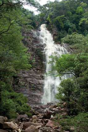
Breaking our slumber and the chugging of the engine Tony landed in the middle of nowhere and indicated that we should follow him along a trail towards the cliff. His escapade took us over a pile of enormous rocks to the foot of a waterfall, that he said he had named Rock Falls, with great originality. It was about 100 metres tall and the sight of the water cascading down and bouncing off the rock over tens of storeys was mesmerising. Suddenly a rumble of thunder interrupted our meditation. We ran back to our final camp, Tukeit. The water from the plateau above us streamed into the path, and we saw rivers swelling up from nowhere and rising before flowing into the Potaro.
Once back in the hut, and safely settled in our hammocks, we had time to chat with our helpers and find out more about this country that in fact we had only glimpsed so far. Apparently the government had acted very quickly to take the situation of the Amerindian people into account. An ‘Indian Act’ was passed, granting the Amerindians a certain degree of autonomy and the right to manage their territory. We also learnt what they thought about the fascinating history of Guyana.
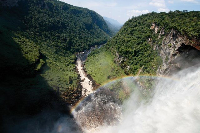
The final trek to the falls would be by far the most difficult, according to Tony. An infamous climb awaited us, but our impatience spurred us on. After having got through a passage known as ‘Oh my god!’, we could hear the thundering of the Kaieteur Falls. We started going through an extraordinary landscape with enormous giant tank bromeliads that were endemic* to the place. The ground was bare granite. The path became narrower, passing between vast rocks before leading out onto a plateau. A kilometre of empty space stood between us and the Kaieteur Falls, an entire river falling uninterrupted from a height of 250 metres where a sheer break marks the end of the plateau. In the distance about one hundred kilometres away you could make out the mountain chain of the Guianas – the Tepuys. These mysterious mountains lie on the Venezuelan and Brazilian border and some of them are almost 3000 metres high. We went back to base camp along the foot of the cliff. It was a little modestly furnished wooden house with an old English military map of the region on prominently display. We met a woman of Venezuelan origin in charge of the cooking, two American researchers in herpetology, a Guyanese biology student and the site warden, a fifty-year-old Guyanese man who, like many people we met in this country, was determined, stiff, and energetic.
There are several legends about where the name of the Kaieteur Falls comes from. According to one of them, a very old Patamona chieftain called Kaie sacrificed himself by going over the falls in his pirogue so as to appease Makonaima, the Great Spirit. Another version says that the word Kaieteur comes from the English defamation of an Amerindian term meaning “rumbling man ”.
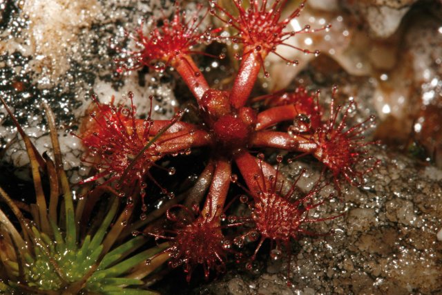
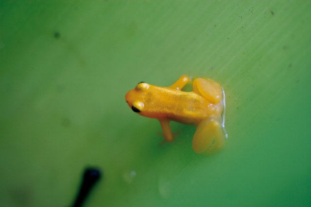
But irrespective of its origin we were happy to spend our time swimming amidst the panoramic views and discovering the site and its many animal and plant species: cocks-of-the-rock, golden frogs (Anomaloglossus beebei) hidden away in the bromeliads, carnivorous plants and white-collared swifts (Streptoprocne zonaris), thousands of which swooped in the air beyond the enormous body of water of the Falls on their way back to their nests in the fading light of day.
The next day we were woken up by the characteristic throbbing sound of a twin-engine plane. It circled a bit before landing on a runway we had not noticed. A few minutes later a dozen tourists got out, and were soon directed by a guide to the various viewpoints. After the habitual photos they all headed back to the aerodrome for their flight back. Their visit will only have lasted one hour in all. If one thing is certain it is that we do not regret the couple of days spent journeying through this beautiful region.
But our time was counted too, and we gave up the idea of going as far as the Chenapou Amerindian community upstream on the Potaro. We said goodbye to Tony who was going to head back down the trail towards Tukeit.
For our flight back to Georgetown we took a rather unpromising looking old English plane, which nevertheless managed to fly over the many vast shapeless scars cut into the forest and with which we were by now familiar, caused by gold and diamond mining, one of the main resources of the country. We arrived safe and sound in Georgetown amidst the jubilant atmosphere of the Carifesta Festival. And so it was only with some regret that we organised the long and beautiful route back towards Cayenne through the three Guianas.
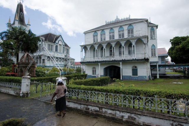
Georgetown’s architecture
In March 2008 during the Easter holidays three teachers and ten final year pupils studying civil engineering at the Balata high school left French Guiana on an epic 2000 kilometre bus trip. Their destination was Georgetown in Guyana.
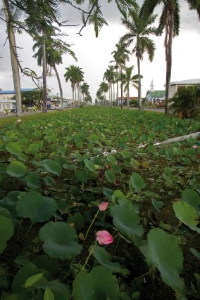
Once there we met men and women who were not very different to us and with whom we spent precious moments enjoying the simple pleasures of picnicking and flying kites. We discovered a town whose architecture tells of an elegant lifestyle inherited from a colonial past. It is a garden city built between the ocean and the Demerara river, where irrigation and erosion by the Atlantic have been brought under perfect control. It is a town with an outstanding architectural heritage standing testimony to the skills in building with both wooden and metallic structures. The shapes and materials are familiar, and there is a certain degree of ingenuity in the solutions to adapt to the climate and lifestyle, with the unique double-skinned windows with Demerara shutters and so-called widows’ towers atop the beautiful townhouses where the wives of sailors used to scrutinise the horizon.
 Voyages avec Tooy. Histoire, mémoire, imaginaire des Amériques noires : Editions Vents d’ailleurs, 2010
 Guyane. Produits du terroir et recettes traditionnelles. L’inventaire du patrimoine culinaire de la France : Editions Albin Michel, 1999
 Alunawalé, un voyage à travers les milieux naturels de Guyane : Office National des Forêts, 2009
 Augusta Curiel, Fotografe in Suiriname 1904 – 1937 : Libri Misei Surinamensis, 2007
